 Svenska
 Español
 English
ПО
Overview
Collect it, Store it, Analyze it!
GaiaSpectrum® is a compact yet powerful set of tools for analyzing and comparing geophysical data collected from different instruments from the same or different manufacturers. It is designed to import all major GPR(Ground Penetrating Radar) file formats, geophysical data formats such as SEG-Y, SEG-2 and a wide variety of laboratory instruments. The data can be viewed in five different ways and there are several tools for automatic and semi-automatic analysis of the data sets.
The source data is imported into the software without making any modifications to the original file. The analysis results can then be stored as reference files for further comparison with other data files.
GaiaSpectrum® has full support for viewing multiple traces without compression and playing back them in a continuous manner. One can pause, play forward or in reverse the imported file without any restrictions of file size or type.[try it!]
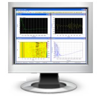
Five Data Views
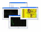 GaiaSpectrum® has five different data views,four of which can be viewed
simultaneously. That is, the imported data can be represented in five
different ways: time domain or oscilloscope, frequency domain or spectrum,
waterfall view from the time or frequency domains and as phase information
against frequency content. The waterfall data view is shared between the
frequency and time domain and that's the reason why only four data views
are available at the time.
GaiaSpectrum® has five different data views,four of which can be viewed
simultaneously. That is, the imported data can be represented in five
different ways: time domain or oscilloscope, frequency domain or spectrum,
waterfall view from the time or frequency domains and as phase information
against frequency content. The waterfall data view is shared between the
frequency and time domain and that's the reason why only four data views
are available at the time.
[user manual]
GaiaSpectrum® has five different data views,four of which can be viewed
simultaneously. That is, the imported data can be represented in five
different ways: time domain or oscilloscope, frequency domain or spectrum,
waterfall view from the time or frequency domains and as phase information
against frequency content. The waterfall data view is shared between the
frequency and time domain and that's the reason why only four data views
are available at the time. [user manual]
Twelve Fully Supported Geophysical Formats and Growing
Importing a file into GaiaSpectrum® is as easy as opening a file in any application for Microsoft Windows®. The equipment manufacturer usually provides fixed values for the most important file parameters. GaiaSpectrum® recognizes all the required parameters on the supported files formats and sets up the options accordingly. After the import is completed the spectrum view opens showing the spectrum of the imported file.
[user manual]
Several Automatic And Semiautomatic Analysis Tools

GaiaSpectrum® counts more than a dozen automatic and semiautomatic analysis tools in its standard configuration. Measurements such as: total harmonic distortion, signal to noise ratio, ground penetrating radar filter boundaries selection and many others are quick accurate and easy to use. From version 2.0 and up DSP techniques such as whitening of the spectrum, FFT filters and gaining the input data, have become available.
[user manual]
Documenting And Sharing Made Easy

It is possible to save the active data view as a bmp or jpg file to add to reports and any kind of documentation. Labels can be easily added to the data view with different fonts and colors. All data views except the waterfall data view have reference data meaning that a file can be saved and sent to your colleague as a reference file. In such a way both of you will see the same results and comparing data becomes easy and reliable.
[user manual]
Overview
GaiaSpectrum® Standard Edition List of Features
 |
1. Time and frequency domain analysis. 2. Phase and time/frequency domain waterfall plots. 3. Fully synchronized playback forward and backward for all data views. 4. Fully automatic toolbars for easy access depending on the data view. 5. One button access to all data views. 6. Windowing functions with view in the time domain. 7. Single trace, infinite persistence (stacked), average and peak hold modes. 8. Direct import from more than a dozen of geophysical and general purpose file formats. 9. Export into GaiaSpectrum® files for quick launch. 10. Export into DZT compatible files, this allows converting other GPR manufacturers into GSSI Inc. compatible data. 11. Fast transforms, FFT size 65536 in just under 100 mS. 12. Padding with zeroes or truncating methods are available for data sets with a non power of two amounts of samples. 13. Low pass decimation tool for continuous wave up to 1:20. 14. Fully customizable scales. 15. Auto scale function for the spectrum analyzer data view. 16. Vertical gain for the o-scope data view. 17. Gain function synchronized in all data views. 18. Palette selection and loading for the waterfall data view. 19. Bar or line spectrum plot. 20. X-Y Measurements in all data views. 21. Color Print-outs with header and footer from all data views. 22. Flip function for the O-scope data view, this is reflected in the time domain waterfall plot. 23. Maximum, Minimum and Peak to Peak measurements for the time domain plot of the data. 24. Reference waveforms for the O-scope data view that can be saved and called upon. 25. Cursors with increment as volts or bits for the time domain plot. 26. Zoom for the time series plot with dynamic playback. 27. Auto tune function for the spectrum data view with selectable bandwidth for the tuned frequencies. 28. Span and center frequency selection tools. 29. Markers with increment measurement for the frequency domain plot. 30. Reference plots for the frequency domain plots that can be saved and called upon. 31. Ground Penetrating Radar filter selection tools. 32. Full set of automatic measurements in the frequency domain for periodic signals. 33. Whitening tool for the spectrum. 34. FFT filters for the data sets. 35. Level tool for finding out bandwidth limits easier. 36. Screen labels available for all data views including the new time domain waterfall plot. 37. Reference functions for the phase data view that can be saved and called upon. 38. Waterfall plot for the time and frequency domain. [user manual] |
Overview
· CSV Comma separated values format
according to CSV format.
· DAT ASCII data (MATHCAD® or MATLAB®) file
with inputs parameters specified in the options menu or dat header file.
· DT (S&S) Ground penetrating radar from Sensors & Software Inc., Canada.
· DZT Ground penetrating radar from Geophysical Survey Systems Inc., USA.
· GSF Ground penetrating radar from Geoscanners AB, Sweden.
· RD3 Ground penetrating radar from Malå Geoscience AB, Sweden.
· SEG-Y Geophysical data exchange format rev 1, 2002.
· SEG-Y (Radsys) Ground penetrating radar from Radar Systems Inc., Latvia.
· SEG-2 Seismic/radar data file based on special report from SEGEGGC.
· SEG-2 (SPRScan) Ground penetrating radar from ERA Ltd, UK.
· SHT wavestar® Oscilloscope data files from Tektronix Inc., USA.
· WAV Microsoft and IBM audio file data format.
· ZON Ground penetrating radar from IDS GeoRadar Division, Italy.
Overview
Minimum system requirements
- Intel Pentium processor 200 MHz CPU clock,
recommended 800 MHz or higher.
- 64 megabytes (MB) of RAM,
recommended 512 MB or higher.
- 10 MB free disk space
plus space enough to import the file.
- 256-color video display adapter.
- Screen area: 800x600,
recommended 1024x768.
recommended 800 MHz or higher.
- 64 megabytes (MB) of RAM,
recommended 512 MB or higher.
- 10 MB free disk space
plus space enough to import the file.
- 256-color video display adapter.
- Screen area: 800x600,
recommended 1024x768.